 We moved int No.10 as a family, that’s dad Ernest, mum Margaret, eldest brother Michael, then Phillip, sister Beverley and me three, year old David, that was in 1951. My only memory of it then, is that the lawn grass was about a foot tall, it had probably been empty for quite a time. That may have been because, as we later found out it flooded badly from the river Soar, twice while we were there, from my recollection, but it could have been more. We certainly always kept an eye on the water level in the field next to us, in fact there was a floorboard we would lift in the end room where we could watch the water level rise.
Flood alleviation schemes for the village had been discussed by the local council since at least the 1930’s if not before.
Prior to us, and from about 1948 the Pickerings lived there. Mr Pickering worked either at Croft quarry, or Empire Stone in Narborough, as a lot of people did. Four times every working day their siren would sound for the start and end of working hours at the “Empire”, it could be heard all over the two villages and probably a lot further. Mrs Pickering prior to moving to No.10, had kept an old thatched pub in Huncote but this was condemned and demolished. It stood in the middle of a row of cottages that existed where the Red Lion car park is now. Son Jack was the eldest and he later married Joan Bingley who kept her father Cyril’s shop at 25 Station Road , there was Brian, Christine, and youngest son known as Sonny.
Within three years they had moved to Narborough into one of the villas between the fish shop and the dairy. Had it flooded while they were there I wonder? They certainly moved to higher ground!
Before them were the Spiers family, Herbert b.1899, wife Gladys b.1898 and children Eric b.1918, Dorothy b.1920, Lilian b.1922, and Maurice b.1923. Herbert worked at Empire Stone and later became a director. They were definitely there at the time of the 1939 register taken on the 29th September that year.
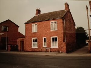
Originally built somewhere between c.1790 and 1830, the clues being, hand made bricks of irregular colour, with fine lime mortar joints, and subtle flat brick arches over the windows. Also the central doorways and general symmetry are typical of the early 19th century, as was the local Swithland slate roof.
The front elevation was completely re-skinned, and sash windows added either in the late 19th century or early 20th. The clues to this are the machine made bricks laid in English bond, and the sash windows, also looking at the right hand side wall there is clear evidence where the later brickwork is tied-in (I’ve known this house for over 70 years but only spotted that last bit from a closer look at an old photo, recently!).
At some point after this, and probably in the late 1940’s, the centre doorway was bricked up and a sash window fitted. A porch was then added to the left hand side, forming the front entrance, and a garage, set back from the road, was added. All of this was in not very attractive common brick. At the same time the boundary with the field known as Biddles Meadow was enclosed in the same brick, with a wall between 3 or 4 feet in height, this returned on the rear boundary to meet the 2-storey barn which stood at the back.
Inside were two reception rooms of about 12 feet square at the front, one, the left hand having a wooden floor as already mentioned, and the right hand one solid with a red and green tiled floor. Both had fireplaces, one being early Victorian, the other a later tiled replacement from the 1930‘s. The two rooms at the back were of similar size, one being the kitchen, again with original red tiled floor, and a central back door out into the garden, the other was a large pantry with a solid screeded floor. It was shelved, there were several hooks in the ceiling for the hanging of meat etc. One half of the sliding casement window was of a fine gauze mesh.
The four rooms upstairs were accessed by a steep staircase which was to the right of the back door as you entered, after three treads it turned sharply left to arrive on the landing. Of the 2 smaller rooms at the back one had been converted into a bathroom, large and freezing in winter, and with the longest cast iron bath I’ve ever seen.
The two front bedrooms were another step up from the landing, both originally had fireplaces.
Outside there was a largish garden and as mentioned a 2-storey barn, at the bottom of the garden, and directly in line with the back door was a gate giving access into a cobbled yard, the barn and a run of stables.
So was number 10 at one time a farmhouse with its barn and stables behind?
The tithe apportionment map of 1853 (Littlethorpe Maps) is the earliest village plan available before the first ordnance survey map of 1886 (Littlethorpe Maps). Although this may show No.10 as plots 23 and 24, and in the ownership of John Jacques, with William Harriman the occupier, the map isn’t necessarily deadly accurate, or show all of the properties, only those that had previously been liable to pay tithes. Having said that plot 23 is the possible location, we can’t say more than that.
Thanks to Nev Duncan for his knowledge of the residents prior to us.