Field names have always fascinated me, as a kid I had on my bedroom wall a large scale ordnance survey map showing part of the village and some of its fields. The best part for me was that the fields actually had names, from memory these were printed and it’s how the map was issued but it’s a long time ago, were they inked in? Almost seventy years later despite searching I can’t find anything similar, in fact that search was most likely the start of this village history. Fortunately I found in the local record office a survey carried out by the local women’s institute in the 1970’s showing and naming the fields, shown below.
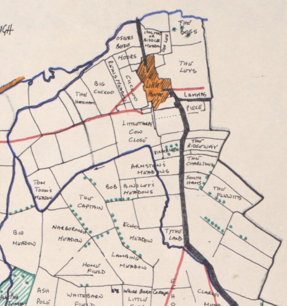
Village field plan as drawn by the local W.I in the 1970’s, Their research is logged at the local records office.
The field next to my house I discovered was called Biddles (the name Biddles was synonymous with Littlethorpe) Meadow it was situated between us and the river Soar, a quick hop over the garden wall was all that was needed to explore the nearby fields and fish the river. Biddles Meadow in my childhood always had Lapwings, known to us as “Peewits” because of their call, returning to nest each spring. Later the field would be cut for hay.
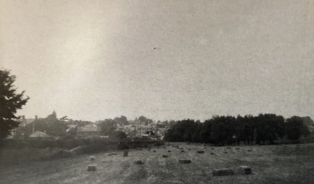
Biddles Meadow with hay bales C. Summer1962
Below is a list of field names from around the village. Some have measurements with the size in acres, roods, and perches. An acre is roughly the size of a football field, a rood is about one quarter of an acre, and a perch is about 22 square yards.
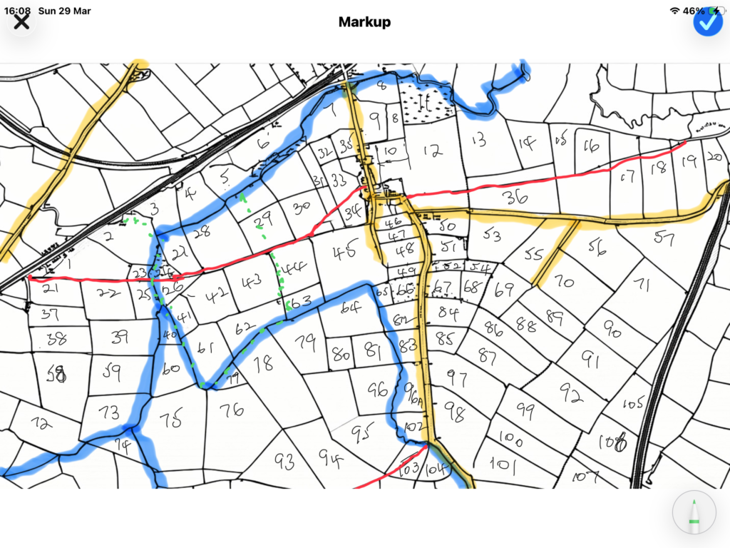
The map shown left gives a numbered key to all of the Littlethorpe village fields listed below.
Armstons Meadows 6a
Big Cuckoo 7.7a
Big Meadow
Biddles Meadow 2.8a
Bob Bingleys Meadows
Bottom Leys 3a 2r 28p
Cocksfoot 5.8a
Cuckoo 2.1a
Dog Leg 4a
Dowells Close 7a – grazing land – owner/occupier – Thomas Hudson – L.J.20/6/1817
Echo Meadow 11a 1r 24p
First Blake Furlong 6a 1r 22p – pasture – south end of Whetstone Road – occupier – Mr Kenney – L.H.25/8/1830
First Cowford Meadow 2A 1r 9p fronts A46
First Echo 7a 2r 29p
First Moor Meadow 3a 2r 10p – arable – south end of Whetstone Road – occupier – Mr Kenney – L.H.25/8/1830
First Close 2.1/2a – arable – upper end of village – owner/occupier John Hobill – L.J.2/8/1844
Forse Close 1a 1r 30p
Hollow Meadow 5a 0r 18p
Home Close 4.1/2a – behind Old House Farm – owner/occupier – John Hobill – L.J.2/8/1844
Hovel Close 11a 3r 2p
Langham Bridge Meadow 1a 3r 34p fronts A46
Lammas Piece
Littlethorpe Cow Close 10a
Middle Close & Road 6a 0r 10p
Moors 2.6a
Moor Meadow 9a 1r 3p – arable – South end of Whetstone Road – occupier – Mr Kenney – L.H.25/8/1830
Narborough Meadow
Narrow Close 4a 2r 25p
Osier Beds 5a 2r 29p
Rittins Meadow 2.2a
Second Blake Furlong 8a 1r 36p – arable
Second Cowford Close 1a 0r 13p
Second Echo 8a 1r 1p
Second Moor Furlong 4a 1r 38p – arable – Southery end of Whetstone Road – occupier Mr Kenney – L.H.25/8/1830
Southery Hams
The Bogs 5.5a
The Captain 10.7a
The Charltons 3.5a
The Hatcham 4.6a
The Homestead 2r-close to littlethorpe on Cosby rd.
The Leys 13.6a
The Plewitts
The Ridgeway-bingley 2.8a
Three Corner Close 7a 0r 16p
Tom Toons Meadow 5.3a
Top Close 8a 1r 26p
Top Leys 14a 1r 11p
Tythe Land 2.2a
Vineries-nursery 1.6a
Sources: Leicesterhire Records Office, Tithe Map 1853. Narborough & Littlethorpe W.I., various ordnance survey maps, dave thompson collection,
As with any local history research continues on this and more information will hopefully be added as it is found, so keep checking for the latest updates. In fact if you can add anything to the above please get in touch via the contact form