Turning Left off Station Road into the Square. The Old Inn located on the corner.
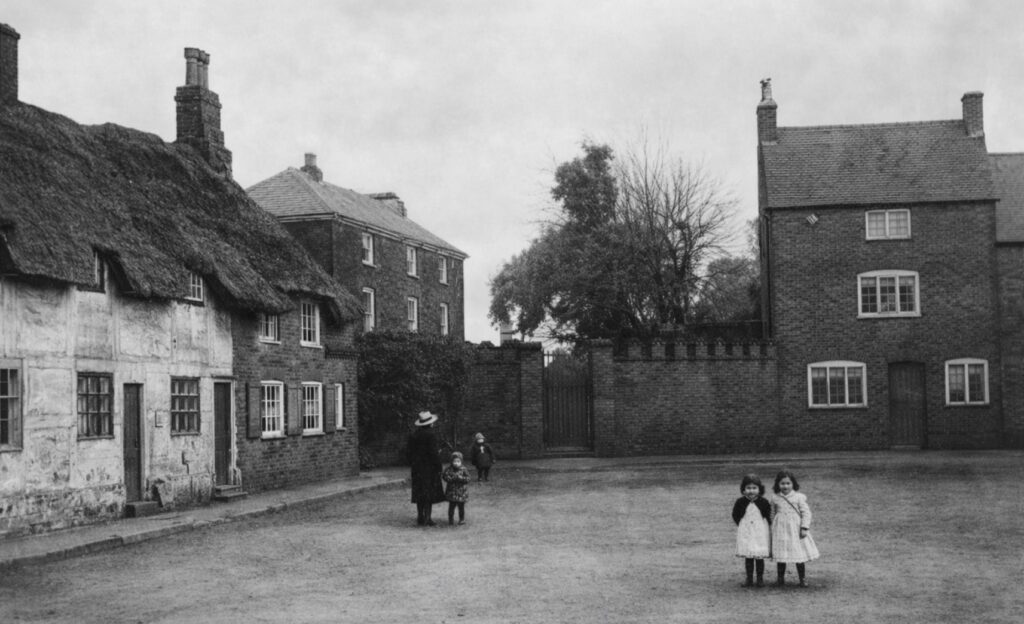
The Square C.1900
The yard entrance after the inn provides access to the rear of cottage numbers 4 and 6 (No. 18 on the plan below). These were originally timber-framed with wattle and daub infill, and had thatched roofs, likely dating from the late 17th or early 18th century. They were refronted in brick in the 1920’s, and the thatch replaced by slate. The work was carried out by Abraham Bingley’s building firm. Abraham had his yard and workshops at The Ridgeway on Cosby Road (an article in waiting).
Behind these set back in the corner was a now-demolished simple framework knitters cottage (No.17 on plan)
Number 8 (No.19 on plan) in the corner was the Joiners Arms, for many years occupied by The Biddle Family.
The rear yard of The Joiner’s Arms was entered through a small covered yard (No.25 on plan). The yard enclosed the pubs brew house (No.20) on the left hand boundary. On the right hand boundary adjoining Littlethorpe House there were five or six basic one-up, one-down thatched cottages (No’s 21-25 on plan), on the right (also see the plan attached to the Joiners Arms article). These were the homes and workplaces of the framework knitters and their families. The census returns of the mid 19th century incredibly show as many as 10 people inhabiting just one cottage. They had fallen into dereliction and were demolished in the 1950s.
Littlethorpe House and adjacent properties in it’s ownership (No’s 26-38 on plan)
Left-hand corner: entrance to Littlethorpe House (26), built circa 1783.
Turning left past the Littlethorpe roll of honour, and just behind it, is number 12 (27), a three-storey house (circa 1840–1860).
Next door: number 14 (28), the middle cottage, then number 16 (29) on the corner, now combined into one property.
The Narrows and Narborough Lane Yard (No’s 30-38 on plan).
Continuing left, before entering The Narrows, there was a gateway entrance into what was formerly Narborough Lane Yard. A yard of eight two-up, two-down cottages dating from the late 18th or early 19th century, again simple workers homes and workspaces predominantly occupied by framework knitters in their heyday.
Three cottages in the yard faced towards the rear of numbers 12, 14, and 16 (27-29).
Five cottages in The Narrows, faced the farm cow sheds and farmhouse (39) going towards Cosby Road corner, all eight cottages sharing a row of privies (38) in the yard at the back.
All disappeared with demolition in the 1970’s enabling the widening of the road.
Farmhouse and Spring Gardens
Behind the farmhouse (39) was an entrance leading to fields, and two simple cottages (40), later merged into one property.
Returning to The Square and turning left was an old farmhouse (41), this was rebuilt by Hubert Bingley the builder as his home, retaining the old farmhouse kitchen inside. The plot adjacent between that and the farm (39) he used as his building materials storage yard.
Behind this, at right angles was Wide Lane, otherwise known as Carcass or Slaughter House Lane, because it led to Tom Bingley, the butcher’s pig sties and slaughter house. (see photo below)
The lane had a run of five mid-18th century two-up, two-down, brick built cottages known as Spring Gardens (No’s 42-47)
Running at right angles, were four more similar cottages returning to Wide Lane. (48-51). All of the cottages shared outside privies.
Now crossing over Wide Lane (which then turns right and continues on to Littlethorpe Lodge Farm).
On all of the left hand side were the farm outbuildings, ending with the farmhouse (57) at the top as the lane enters The Square. In the 1930’s this was farmed by Harry Tomlinson, who on retirement took on the little off-licence in Church Lane, Narborough. The 1950’s saw it farmed by the Hallam family.
Numbers 5, 3, and 1 (58, 59, & 60) complete The Square.
So was The Square originally the village green?
It’s earliest existing property, the timber-framed, now brick-fronted cottage on the left, dates from the late 17th/early 18th century, making it one of the oldest surviving properties in the village, along with Littlethorpe House Farm (8), and the oldest thatched part of The Plough Inn (79).
Other cottages around the square: likely date mid to late 18th century.
Littlethorpe House in the corner built circa 1783.
Cottages dating 1840–1860 face what would then have been open fields across The Square, prior to the building of No’s 45-49 Station Road around 1900.
The Square therefore likely formed the original village nucleus, around a village green and sensibly situated on higher ground away from the River Soar flood plain.
Over the years it was used for many village celebrations, including VE Day in May 1945, and followed by the coronation of Queen Elizabeth II in 1953 (see attached photos).
Sources:
As with any local history research continues on this and more information will hopefully be added as it is found, so keep checking for the latest updates. In fact if you can add anything to the above please get in touch via the contact form
My thanks as always to Nev Duncan for a lot of the information in this, and for the photo’s & newspaper clippings included.